0 km The route starts at the roundabout near the entrance to Tarrés coming from the N-240 road. Take a left turn at the roundabout (one of the paths to Tarrés). About 30 meters away, you will find a car parking area.
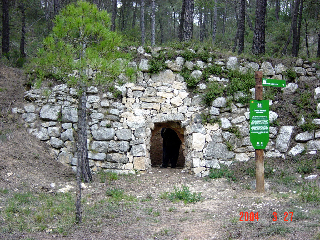
0.5 km Take the road on your left. (Raised above the entrance to the trail is a Lime Kiln, (forn de calç) you can visit). Continue the route following the path.
0.7 km There's a crossroads where four roads meet. (If you take the first left, and follow for 0.5 km you will find El forn Nou, a quarry and a viewpoint with a panoramic view). To continue with the route, go straight along the path that ascends from the crossroads.
0.9 km You now reach a fork. (The road on he left leads to Fulleda), continue the route to the right.

1.3 km (There's a footpath to the Forn de la Comardivina del Ros (100 metres)). Continue on the main path, keep straight.

1.9 km You reach another fork. (If you turn left, in 140 metres, you arrive at Forn dels Assèguils del Rabadà.) Continue to the right to follow the route.
2.3 km You reach an esplanade, where there used to be a quarry. (There's a road to the right)  follow the road to the left.

2.35 km You now have reached another esplanade Toll de la Gravera. (If you go to the left, in 60 meters you'll arrive at the Forns Bessons of Pla del Xató). Go right to follow the route.
2.4 km The road branches in two, follow the road to the left.

2.5 km You reach another fork. (If you turn left, in 30 meters  take the path  to the Forn dels Assèguils de Joan del Roig (170 meters away)). To continue the route, take the first turning right.

3.3 km The road will take you to the Forn del buscarró del Pubillet. To continue the route, please, take the ascending path on the right  (cyclists will have to carry their bykes for  50 meters only).
3.4 km When you reach the flat top, continue on the path to the right.

3.5 km There is a footpath on the left. (If you take this path, you will arrive at Forns del Buscarró de la Pura (30 meters away)). To continue the route, keep straight on.

3.7 km You approach another path, continue on the left. You will find a crossroads; again, take the road on the left, which gradually turns into a footpath.

4 km You will reach a main road; continue on the left.

4.6 km Please take a secondary road on the left, it gradually turns into a footpath;

4.8 km There is a new path on the left. (If you follow it, in 2 meters  you will find kiln Forn del Buscarró del Paris). Continue straight to follow the route.

5.1 km You will find a path on the right and one on the left; continue on the third one  straight ahead.
5.4 km There's a footpath on the right. (If you follow it, you will reach kilns Forn de les Comes de Montgrat del Pujol (10 meters away) and the old Font del Pujol (15 meters away). To continue the route, keep to the path you have been following.

5.5 km You find an esplanade on the left. (Descending, there are the Forns Bessons de les Comas de Mongrat del Ros (25 meters away)). Continue downwards the main path to follow the route.

5.8 km You reach a crossroads; continue straight on the trail.

6.2 km You arrive at Fondo de les Comes de Mongrat. Continue straight along the path.

 6.5 km You arrive at Forn de les comes de Mongrat del Mosset. It is on the left of the road. Continue along the meandering path  towards the upper plain.
6.8 km Now you have reached an agricultural area; continue for 130 meters on the left along the farmland until you reach another path.

7.2 km You approach a main road, turn left.

7.4 km Before reaching the new road, turn left at the lamp post onto a path.

7.45 km On the left there is  Forn del Pla Ferran.

7.6 km Cross the road and continue straight ahead on the road ahead.

 7.7 km Continue straight on the main road.

7.8 km (If you take a path on the left, you  reach a cabin with a vaulted roof and if you turn right in 50 meters there is Forn Gran de l'Arbós). Continue straight on the main road.

 8.1 km You now reach a fork in the road. (If you take  the main road on the left, in 430 meters there´s a lime kiln and in 660 meters- a panoramic view). Continue the route, taking the road on the right.
8.2 km (On the left there´s vaulted cabin of Plans del Fuster), continue straight on.

8.5 km (There´s a path on the left), please continue straight on.
8.6 km ( There is a footpath on the left; if you follow it you will reach the Forns del Colomet in Codoç (50 meters away). Continue straight on.
8.65 km (There is a footpath on the left; if you follow it you will reach the Forn del Colomet al  Codoç and the Pedrera (quarry) of the same kiln (40 meters away). Continue straight to follow the route.

9 km You reach a main road. You are in Plans de Tarrés. (If you go left, in 250 meters you will reach a panoramic view and in 280 meters- a lime kiln). Continue on the right to follow the route.

9.3 km (There´s a path on the left; if you take it, in 70 meters you  arrive at a kiln Forn Bessons de les costes de les Eres.) To continue the route, go straight.

9.5 km (There´s a trail on the left; if you take it  in 110 meters you arrive at Forn de les Costes del Mosset.) To continue the route, go straight.
9.7 km (There is a path on the left; if you take it in 150 meters you will reach lime kilns). To continue the route, go straight.
10.1 km You now reach a fork in the road (If you take the middle path in 60 meters you reach Forn del Curull de l'Engràcia). If you continue straight on the main road, you will follow the route.
10.2 km The road branches out, turn left.
From here you can follow the road to Tarrés (1.8 km away). If you prefer, you can return via the Lime Route by retracing the path taken initially (about 2.5 km).

10.3 km To continue the limestone route, go 100 meters along the road and take the path on the right, which leads to the gravel pit.
10.4 km Take the path to the left.

10.8 km You reach a crossroads; take the path on the left.

11.4 km (You will find a path on the right), please continue straight on the main path.

11.8 km Take a path on your left.

12 km You reach a crossroads; continue straight on the descending road.

12.2 km You reach a main road, turn right.

12.7 km You have arrived at the starting point of the route.